Key points
- NARCliM regional climate projections benefit all NSW residents and sectors.
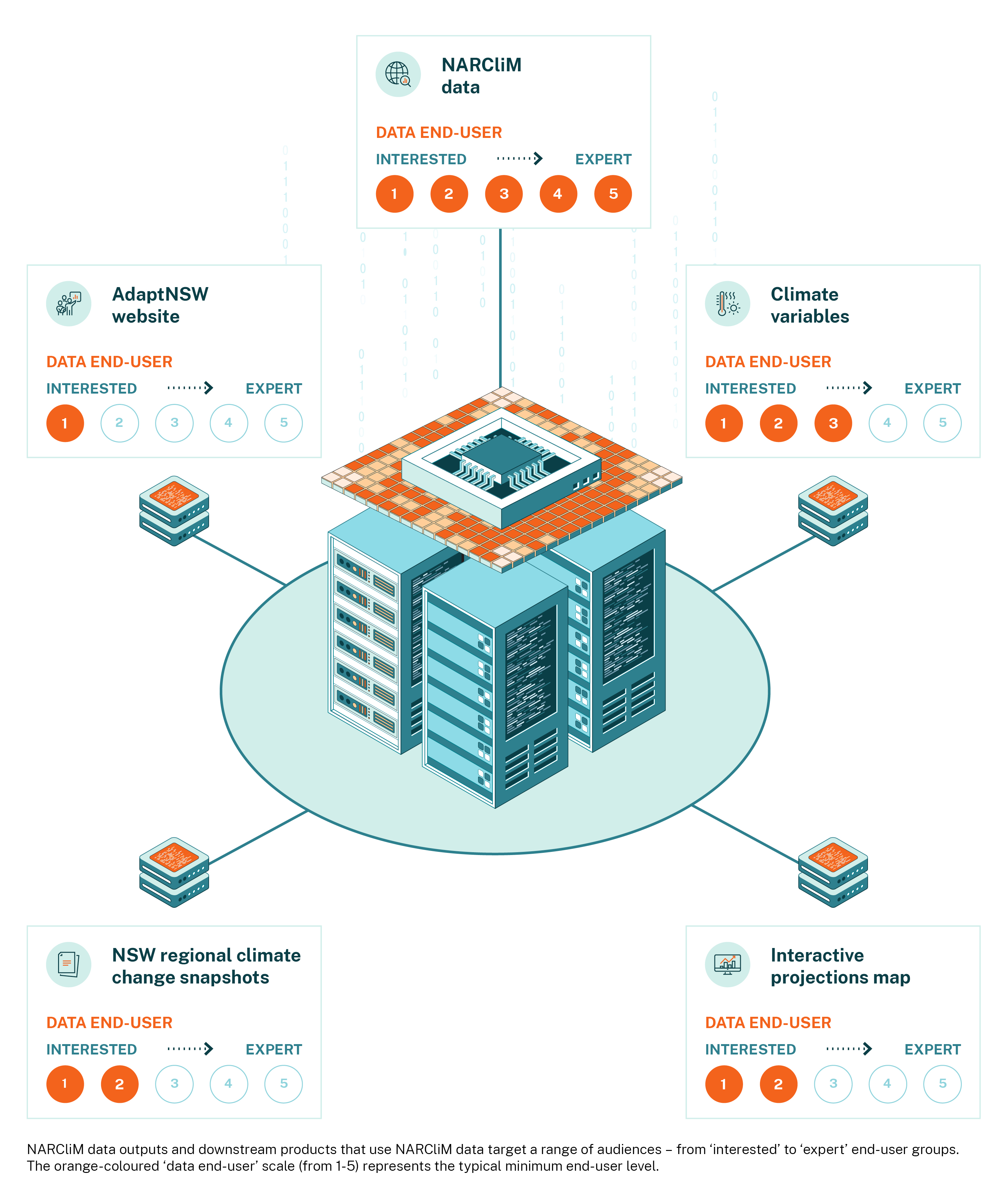
- NARCliM data are used to inform a variety of resources that meet the needs of end-users with different levels of knowledge and technical expertise.
- The NARCliM project considers the needs of various end-users to design the best approach to producing climate data and supporting information and products for NSW.
Making climate model data and information more accessible to diverse end-users
The NARCliM project creates regional climate data, including climate projections. A range of user-friendly NARCliM products are available. NARCliM data and products can be used to inform regional planning and decision-making, such as for conducting climate risk assessments for local government areas, state-owned corporations and utilities. For expert end-users, these data are available in their raw form for analysis and research.
Understanding how best to engage with NARCliM data and products
Broadly, there are 5 groups that use NARCliM data and products. These end-user groups are described below and are listed in order of their familiarity with using climate data. NARCliM data informs a range of information and products to suit the needs of these different end-user groups. Many of these groups will interact with the information to fulfil their climate-related purpose. For example, practising end-users may communicate information to interested audiences, or contract support from experienced and expert end-users.
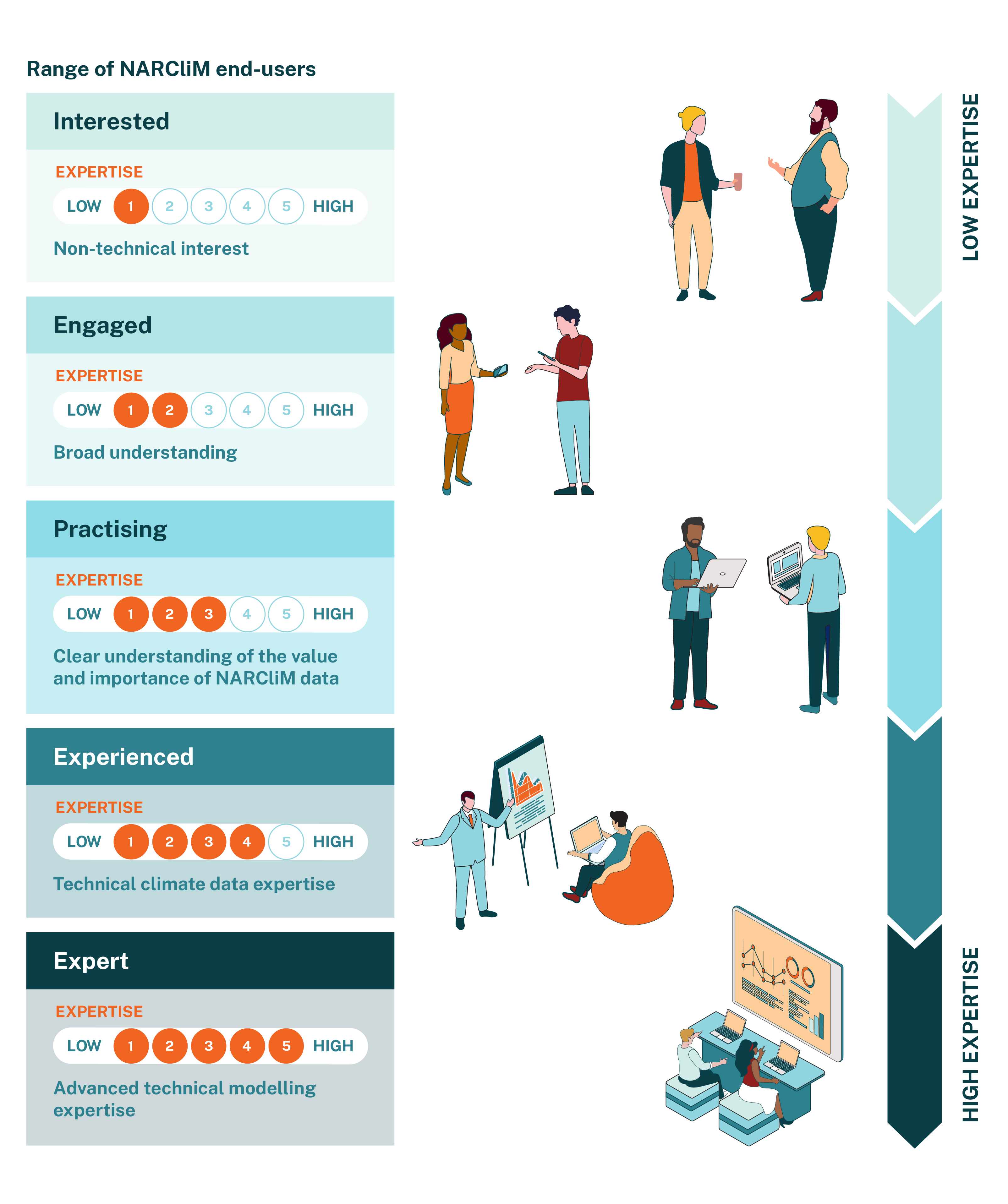
This group of end-users has a limited understanding of climate change concepts. They benefit from receiving support to understand NARCliM data and complex climate information, such as through plain-language climate change information on the AdaptNSW website.
This group has a broad understanding of climate change and is engaged in climate change adaptation – for example, through their work, either professionally or as part of a community group. They want to understand the basics of NARCliM projections, including their high-level uses and limitations. They seek NARCliM-informed products, such as AdaptNSW regional climate change snapshots and NARCliM case studies. They often work alongside more advanced end-users – experienced or expert – who can analyse and apply NARCliM data.
This group recognises the value and importance of NARCliM data, and actively applies the data to their work. They have a clear understanding of their region’s key climate change issues and adaptation needs. They may not work directly with NARCliM projections but are part of a team that outsources or project manages a climate projections project, such as a detailed climate risk assessment or an adaptation planning project. This group benefits from the information on AdaptNSW, including the Climate Risk Ready NSW guide and the interactive climate change projections map.
This group has technical expertise using climate projections. They access and use NARCliM projections and are familiar with using large datasets. They provide expertise in NARCliM data analysis, either as inhouse experts or as consultants to the engaged and practising end-user groups. This group accesses peer-reviewed literature, technical papers and technical information about NARCliM from the NSW Climate Data Portal.
This group has advanced technical expertise in developing and analysing raw and post-processed climate model data. These end-users include climate scientists and climate risk specialists who use models and climate model data for highly technical work. They have technical expertise in developing and using climate models and are specialised in NARCliM data analysis and interpretation. This group accesses data and technical information from the NSW Climate Data Portal.
NARCliM data and products
The AdaptNSW website is the main source of climate information for the interested and engaged end-user groups. This information has been summarised from NARCliM data. End-user groups who need more detailed information can find research, and access NARCliM data and technical information through the NSW Climate Data Portal.
Not all products use all NARCliM generations. Check which generation of data each tool is built on to make sure it meets your needs.
These snapshots show the projected climate changes for all of NSW and the ACT, and for each of the 10 planning regions in NSW. The snapshots combine text and climate maps, detailing projected changes in:
- temperature
- number of hot days and cold nights
- rainfall
- severe fire weather days.
Snapshots based on NARCliM1.0 are now archived.
Format and availability
Webpages, with downloadable PDFs.
Technical expertise needed
The snapshots are ideal for engaged and practising audiences. Other end-users can also use the snapshots to get a quick understanding of projected climate change for NSW regions and the ACT.
Uses
The snapshots describe expected changes at a regional scale, which can be used to guide planning and inform stakeholders. To maintain accuracy, we recommend that users copy and use diagrams and text directly from the snapshots, referencing the source.
For more targeted information (such as the city or town level), use more technical products such as the interactive climate projections map (see below).
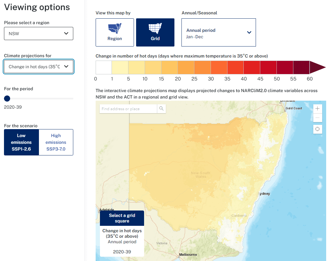
Use the AdaptNSW interactive climate change projections map to visualise NARCliM2.0 climate change projections at a 4km scale for your neighbourhood and region. You have the option of selecting 3 emissions scenarios, multiple variables, and different frequencies and time periods.
- average (mean), maximum and minimum temperature
- rainfall
- hot days (35°C and above)
- cold nights (below 2°C)
- severe fire weather days [FFDI (forest fire danger index) over 50].
Format and availability
Webpage with visual map interface and downloadable projections maps (JPG format) and projections map and statistics data (GeoTIFF and Excel format).
Technical expertise needed
Basic data literacy is needed to interpret the projections maps. Engaged and practising end-users can use the supporting information to help them interpret the maps. All end-users can use the maps to get a quick understanding of projected climate change in different NSW regions. Consider your project needs and desired outcomes when choosing parameters such as climate variables, time periods and emissions scenarios. To use the GeoTIFF files, end-users will need expertise in mapping and GIS software.
Uses
Use the downloadable maps as visual tools to engage audiences with projected climate changes. Maps can be directly copied and used, referencing NARCliM as the data source.
You can also generate your own projections maps using the GeoTIFF files in a GIS app.
The NARCliM methodology as well as performance and application of the data are explored and evaluated through the scientific peer-review process. The climate scientists who develop NARCliM, as well as end-users, have published their research in a range of international journals, pioneering new approaches and advancing the field of knowledge.
Format and availability
Online articles available through journal databases and on the NSW Climate Data Portal and the AdaptNSW website.
Technical expertise needed
Literature on designing and implementing projects will help experienced end-users understand broader considerations, limitations and potential applications of NARCliM data. Expert end-users can refer to the literature on the more technical issues (for example, reviews of model performance for different locations, variables and applications) to inform their own data analysis approaches.
Uses
Scientists access the literature to build their understanding of this research area including current state of knowledge, novel methodology and application.
NARCliM computes local-scale climate projections based on the information provided by its selected global climate models. This information usually includes atmospheric states like temperature, humidity, and wind patterns, along with factors such as sea surface temperatures, greenhouse gas concentrations, and land surface characteristics. NARCliM then simulates the climate based on these conditions and generates data at regular intervals of the time period being simulated. For efficiency, the raw data is output at hourly or 3-hourly intervals.
However, these outputs may not be directly usable by end-users due to their format and resolution. To make the data usable, the NARCliM team conducts post-processing to convert the direct outputs into usable climate variables.
Format and availability
Download a range of climate data as NetCDF, GeoTIFF or CSV files from the NSW Climate Data Portal.
NARCliM post-processed data are available at daily, monthly and seasonal timescales for a wide range of climate variables (such as temperature, precipitation and wind speed) for different plausible future climates.
Currently, there are around 15 variables available for each NARCliM generation. However, the exact variables provided differ across generations.
Four of the post-processed variables on the NSW Climate Data Portal are also available in bias corrected format (mean, minimum and maximum temperature, and daily precipitation).
For NARCliM2.0, expert end-users can also access approximately 150 variables via the National Computational Infrastructure (NCI). Data for these variables are available from sub-daily to monthly timesteps.
Technical expertise needed
Post-processed NARCliM variables are more user-friendly than the raw data. However, a high level of technical expertise is still required, usually that of practising or experienced end-users. The NSW Climate Data Portal provides technical details and instructions on how to download the data.
Uses
NARCliM variables are most appropriate for use by data scientists and expert researchers and consultants. They may be used, for example, as the basis for a targeted analysis of the impacts of the projected changes (such as on biodiversity or health and wellbeing).
Unless otherwise stated, all data and materials on the NSW Climate Data Portal are licensed under the Creative Commons Attribution 4.0 International (CC BY 4.0). The licence terms can be viewed at Creative Commons. Users should also read the Terms and Conditions for NARCliM data and formally acknowledge where NARCliM data has been used.
Following extensive stakeholder engagement and comprehensive research and analyses, NARCliM data are initially delivered to users as post-processed model outputs (see NARCliM variables above).
You can also request raw data (not bias corrected or post-processed) – for example, if you want to run your own bias correction process to more closely match your region of interest.
Format and availability
Download a range of climate data as NetCDF, GeoTIFF or CSV files from the NSW Climate Data Portal .
Email any requests for raw (not bias corrected) NARCliM data to [email protected]
Technical expertise needed
Only experienced and expert end-users will be able to work with raw NARCliM data.
To use NARCliM data, you’ll need:
- experience using large datasets and climate projections – or access to that expertise
- an understanding of uncertainty in climate projections and how to communicate it in your results
- an understanding of when to use bias corrected data (for example, if your assessment only needs temperature and/or precipitation data, or if your application is sensitive to nonlinearities (such as thresholds) in precipitation or temperature).
Uses
The model outputs (data) are most appropriate for use by climate modellers and highly trained data scientists and consultants. The data can be used, for example, to develop detailed models for specific research or planning purposes, such as modelling natural hazards under climate change. Unless otherwise stated, all data and materials on the NSW Climate Data Portal are licensed under the Creative Commons Attribution 4.0 International (CC BY 4.0). The licence terms can be viewed at Creative Commons. Users should also read the Terms and Conditions for NARCliM data and formally acknowledge where NARCliM data has been used.
As a public product, NARCliM can be integrated with external tools developed outside of the NSW Government. There are many ways users can apply NARCliM data, and experienced and expert end-users will often incorporate NARCliM data into their own models and tools. An example of a third-party tool is the Cross Dependency Initiative (XDI).
Cross Dependency Initiative – XDI NSW Globe
XDI is a spatial risk analysis software tool that helps decision makers manage climate risks to critical infrastructure assets.
The XDI NSW Globe platform supports the State's public sector in the climate risk management process as a climate risk screening tool. The tool identifies, assesses and evaluates risks and adaptation options for assets and risk independence across critical infrastructure types. It integrates hazard information, including NARCliM1.0 and 1.5 projections, asset vulnerability and exposure data to analyse and quantify risks and model asset responses.
The tool quantifies the financial, asset and service impacts posed by climate change, supporting registered government users in prioritising cost-effective adaptation investment.
How to access XDI NSW Globe
The platform is available to NSW Government public employees, including council and agency staff. These staff are usually in the practising end-user group and have a clear understanding of their region’s key climate change issues and adaptation needs. Please request access by emailing: [email protected] noting end-users must have a ‘nsw.gov.au’ email address. Once authorisation and access have been set-up, you will receive instructions on how to log in and access XDI NSW Globe.
Disclaimer: A process is underway to evaluate and understand the end-user needs for a climate risk to assets decision support tool and support services, which will inform the procurement of future tool and service offerings.