Key points
- NARCliM creates regional climate projections for NSW through a process called dynamical downscaling.
- The downscaling process aligns with international best-practice frameworks for creating regional climate projections.
- Each generation of NARCliM uses the downscaling process to create climate data based on the latest available science, climate models and methods. This results in finer-resolutions of NARCliM data.
Downscaling for a local view of climate change
Global climate models (GCMs) are typically at a 300–100km resolution. This resolution doesn’t sufficiently capture the fine detail required for regional and local planning and decision-making. Regional climate models (RCMs) offer data at a finer scale (usually 5–50km). Compared to GCMs, RCMs better reflect:
- small-scale processes, such as storms
- the complexity of the Earth’s surface, such as presence of vegetation and types of land use
- topographical features, such as mountains.
Downscaling is the process of integrating GCMs and RCMs to produce regional-scale climate projections. NARCliM applies the dynamical downscaling method as outlined by the world-leading Coordinated Regional Climate Downscaling Experiment (CORDEX) framework.
The dynamical downscaling process
Dynamical downscaling involves taking a GCM and using it as an input for an RCM. The RCM uses physical principles to determine how the climate system behaves across a particular region, and then produces regional-scale climate data based on the GCM data.
The RCM downscales the large-scale climate patterns of the GCM to the smaller area of interest at a finer scale resolution. RCMs are built on physical principles, similar to GCMs. This means that dynamical downscaling can capture changes in the relationship between large-scale climate drivers and local climates.
Because dynamical downscaling is computationally intensive, climate modellers usually only use a subset of the dozens of available GCMs and RCMs. Selecting the most appropriate combination of models is a major consideration when designing regional climate projections.
For NARCliM, careful selection of GCMs and RCMs means that the modelling process balances the need for a range of future scenarios with computing time and resources:
- Multiple GCMs and RCMs are used to simulate a range of plausible future climates. This helps NARCliM end-users plan for resilience to various future climates – a valuable approach when the future is not certain.
- Limiting the selection of models to only the most appropriate ones ensures that NARCliM data remain relevant to NSW, and reduces the time and resources needed to compute the vast amount of data.
In each NARCliM generation, data are produced for each combination of GCM and RCM for each emissions scenario. This results in multiple datasets within each NARCliM generation.
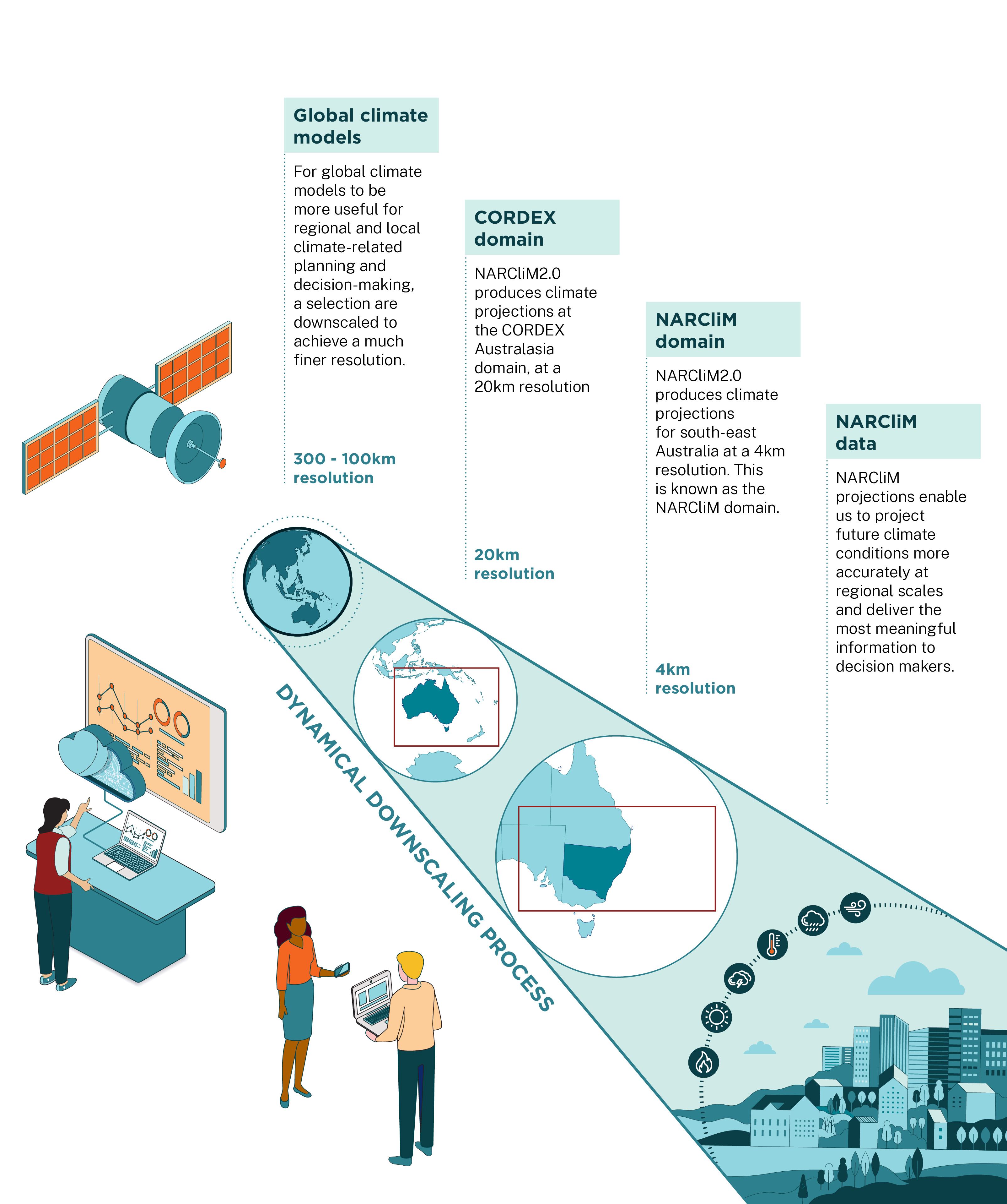
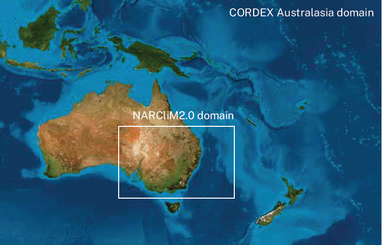
NARCliM and CORDEX domains
In the dynamical downscaling process, the GCM model data are downscaled via the RCM within a defined region. NARCliM produces its regional climate data at 2 scales. For example, for NARCliM2.0:
- The NARCliM domain covers climate projections for NSW, the ACT and Victoria, and parts of the Northern Territory, Queensland and South Australia to a 4km resolution. The capital cities Adelaide, Brisbane, Canberra, Melbourne and Sydney are all included.
- The CORDEX domain covers the Australasian region to a 20km resolution..
Following best-practice climate projection programs
NARCliM uses climate models from the Coupled Model Intercomparison Project (CMIP) and CORDEX. The CORDEX framework coordinates the science and application of dynamical downscaling (also known as regional climate downscaling) across the world.
The World Climate Research Programme (WCRP) govern CMIP and CORDEX. WCRP developed the 2 frameworks to ensure the same experimental protocol (including future climate scenario pathways), outputs (variables and format) and modelling techniques are followed by all contributing modelling groups. This enables comparison and combining of climate models for a vast range of purposes.
To downscale the chosen GCM and RCM combinations, NARCliM applies open source Weather Research & Forecasting Model (WRF) modelling. The WRF system is an international best-practice model for regional downscaling outlined in the CORDEX framework.
The WRF modelling system was chosen for NARCliM because the system:
- is effective in simulating temperature and rainfall across NSW
- can easily be configured to provide good representations of local vegetation cover, land use, topography and coastal processes
- can characterise model uncertainty by selecting different mathematical representations of key processes (for example, radiation, microphysics, convection, land surface) and examine the sensitivity of climate simulations (both hindcasts and projections) to these selections
- is used and trusted across the world.
Improving the process
The downscaling methodology to produce NARCliM data develops over time and improves with each NARCliM generation. This aligns with external improvements in climate models and modelling techniques, such as improvements to the WRF system.